

Up-to-date information on evacuations, shelter locations, school closures, and road closures can be found at the bottom of this article.
[Update: Wednesday, 10:10 a.m.] The Carpinteria Unified School District has closed all CUSD schools and district offices. Air-quality issues persist across South County, and mandatory evacuations remain in effect as far west as Rincon and along Highway 150. According to Cal Fire, “The fire continues to burn actively with extreme rates of spread and long range spotting when pushed by winds. The fire is established on the north and east side of Hwy 150 and is also burning on the west side of Hwy 30.”
[Update: Wednesday, 7:24 a.m.] Cal Fire reports that the fire has grown 10,000 acres in less than 12 hours. The Thomas Fire has now burned 65,000 acres. Total personnel assigned to the fire swelled overnight from about 1,100 to now nearly 1,800. Some 12,000 structures are threatened, and 50,000 people are displaced. Additional mandatory evacuations are in place, and include the communities of Solimar, Mussel Shoals, and parts of Rincon.
[Update: Tuesday, 11:53 p.m.] Multiple media outlets are reporting that the Thomas Fire has jumped Highway 101 near Solimar Beach and is currently threatening homes there.
[Original story: Tuesday, 9:51 p.m.] Much of the stretch of coastal foothills between the City of Ventura and Mussel Shoals burned almost exactly two years ago during the Solimar Fire, but the nearly two-year-old vegetation and series of oil drilling pads in the hills above Highway 101 haven’t stopped the westward growth of the Thomas Fire.
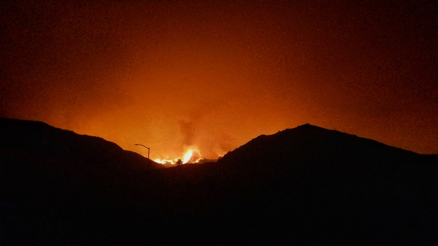
After burning 50,000 acres since beginning on Monday evening, the westernmost flanks of the blaze have breached Madranjo Canyon, just southeast of Mussel Shoals. A Ventura County Fire engine was dispatched from Ventura County Station 25, which happens to be at the mouth of that canyon. According to Captain Dave Zaniboni, a public information officer assigned to the fire, the southwestern flanks of the fire — which include the area burning near Mussel Shoals — are currently the hottest and most active.
The canyons near Mussel Shoals where the fire has arrived mark the halfway point between downtown Ventura and Carpinteria. Now nearly eight miles northeast of downtown Ventura, not 24 hours after burning into the northern edges of the city, the Thomas Fire continues to make its way westward along the coastal range.
“Control objectives” that were established this afternoon by Cal Fire Incident Management Team 4, which is now overseeing fire suppression efforts, clarified intentions to “keep the fire east of Hwy 101” but didn’t establish a containment objective for the western flank of the fire. While winds have died down for the night, high winds are forecast again Wednesday and through the week, when warmer temperatures are set to arrive, further complicating firefighting efforts.

Meanwhile, to the east, mandatory evacuation orders (detailed below) remain in place, with some 29,000 people displaced as of Tuesday evening. Voluntary evacuations were issued for much of the remaining Ojai area early on Tuesday afternoon. Hundreds of evacuees gathered at Nordhoff High School, which has since been established as an evacuation shelter. Nordhoff is one of five shelter locations in Ventura County, while one has opened in Santa Barbara County at UCSB’s Multi-Activity Court, according to Santa Barbara County spokesperson Gina DePinto.
After the Thomas Fire burned into the northern edges of downtown Ventura last night, many active areas remain as crews continue to mop up as they are able. To date, one firefighter has been injured.
Evacuations
Mandatory Evacuations (as of 7:30 a.m. on Wednesday):
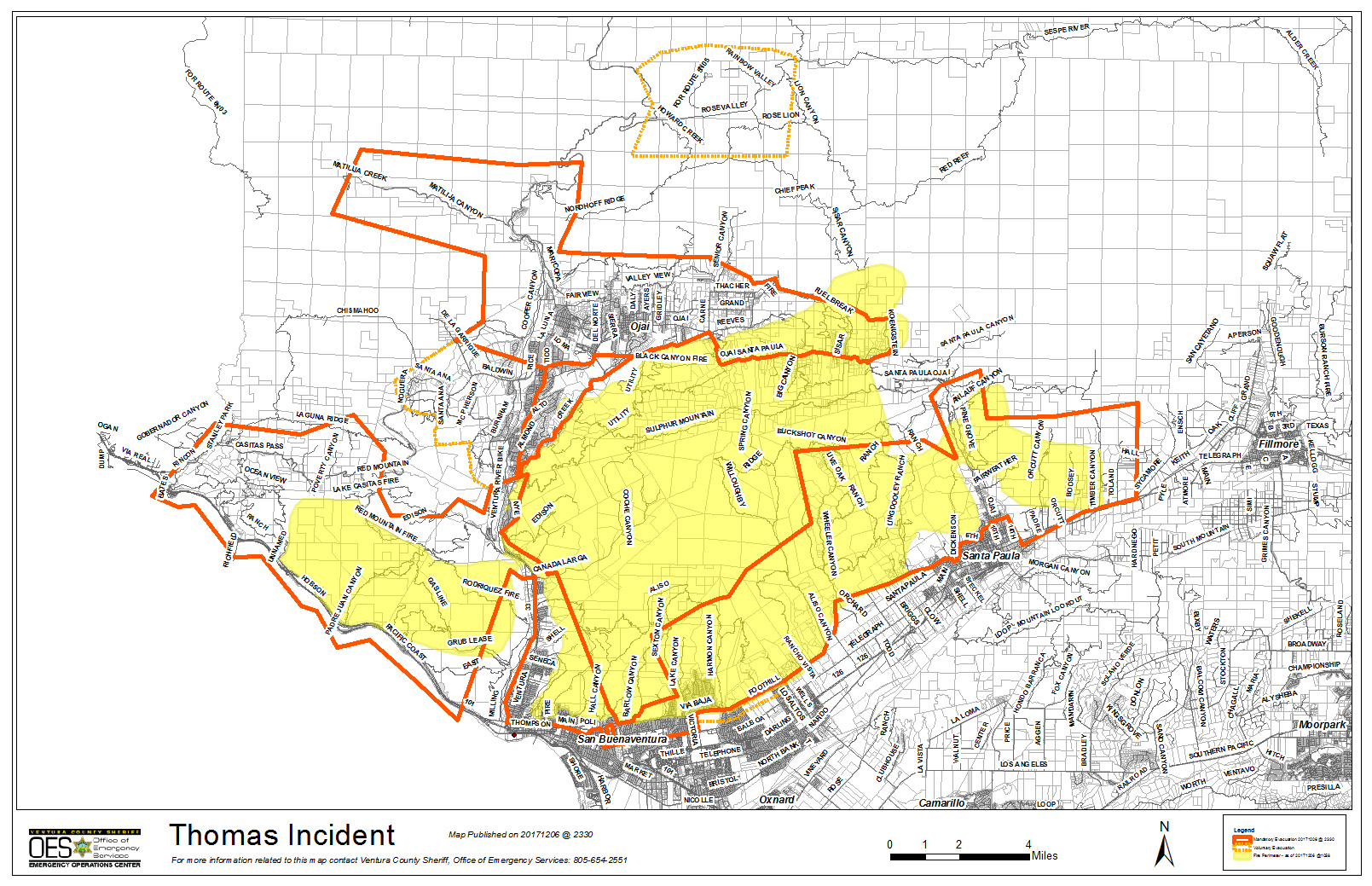

- City of Santa Paula – Boundary of Say Road north to Thomas Aquinas, Dickenson Ranch Road east to Santa Paula Creek
- City of Santa Paula – Boundary of Monte Vista Street north to city limits, Foothill Road from Steckel to Peck Road to north of city limits
- Santa Paula unincorporated area towards Ventura- North of Foothill Road from Peck Road to Wells Road including: Wheeler Canyon, Aliso Canyon and Rancho Vista
- City of Ventura – Teloma east to Brent Street, Telegraph Road north to north of Foothill Road
- City of Ventura – Victoria Road east to Hill Road, Telegraph Road north to Foothill Road
- City of Ventura – North Ashwood Avenue east to Hill Road, Telegraph Road north to Foothill Road
- City of Ventura – North of Foothill Road from Wells Road to Poli Street
- City of Ventura – North of Main Street from Seward Avenue to Hwy 33 (includes entire Ventura Avenue area)
- Oak View – Boundary of Hwy 33, Creek Road and Hermosa Road
- Entire Community of Casitas Springs – Evacuate to Ventura County Fairgrounds – 10 West Harbor Blvd., Ventura
- East Ojai Valley – Carne Road east to McAndrew Road, Reeves Road north to Thacher Road
- Upper Ojai Valley – Hwy 150 from Dennison Grade east to Osborne Road and all residences north
- Ventura County North Coast Area – Boundary of Hwy 33 on the north to Casitas Vista Road, northwest to Hwy 150, Hwy 150 (Casitas Pass Road) west to US 101 and south on US 101 (including Pacific Coast Highway) to Emma Wood State Beach
- Ventura County North Coast Area – Boundary of Hwy 33 on the north to Casitas Vista Road, northwest to Hwy 150, Hwy 150 (Casitas Pass Road) west to US 101 and south on US 101 (including Pacific Coast Highway) to Emma Wood State Beach
Voluntary Evacuations (as of 7:30 a.m. on Wednesday):
- Residents in the City of Ventura, south of Loma Vista, east of Day Road, West of Victoria Avenue and north of Telegraph Road
- Residents in the City of Ventura, east of Victoria north of Loma Vista South of Foothill west of Wells Road
- All residents of the Ojai Valley not currently covered under the current mandatory evacuation
- City of Fillmore: Boundary of 2nd Street north to 4th Street and Island View Street east to Pole Creek
- City of Fillmore – Boundary of 4th Street on the south to Pole Canyon Road, Pole Canyon Road northeast to Goodenough Road, Goodenough Road south to 5th Street and 5th Street southeast to 4th Street
- City of Fillmore – Boundary of Hwy 23 and the Santa Clara River south to Guiberson Road, Guiberson Road east to Torrey Road and Torrey Road north to the Santa Clara River
In Carpinteria, the voluntary evacuation warning is for the following areas:
- All areas from the 5500 block of Casitas Pass Road (Hwy 192) east to the county line to include Lillingston Canyon and Cate Mesa, and all addresses north to the county line.
- All addresses along the east side of Bailard Avenue from Highway 101.
- All areas south of Highway 101 to the coast and east of Dump Road, to include all of the Bates Road and Rincon areas.
- A voluntary warning means residents should prepare their belongings and vehicles should a mandatory warning go into effect. The County of Santa Barbara advises those with mobility difficulties or issues, or who own large animals, to consider early evacuation.
Evacuation Shelters
- City of Ventura – Ventura County Fairgrounds at Miners Building (Red Cross – Includes an Animal Shelter for all types of animals) – 10 W Harbor Blvd, Ventura, CA 93001
- City of Ojai – Nordhoff High School (Red Cross) -1401 Maricopa Hwy, Ojai, CA 93023
- City of Oxnard – Oxnard College Gymnasium (Red Cross)- Open 12/5/17, 0700
- City of Santa Paula – Santa Paula Community Center (City of SP run shelter) – Open 0800
- City of Fillmore – Veteran’s Memorial Bldg (City of Fillmore run shelter), 511 2nd Street – Will be open 12/6/17, 0800 hrs
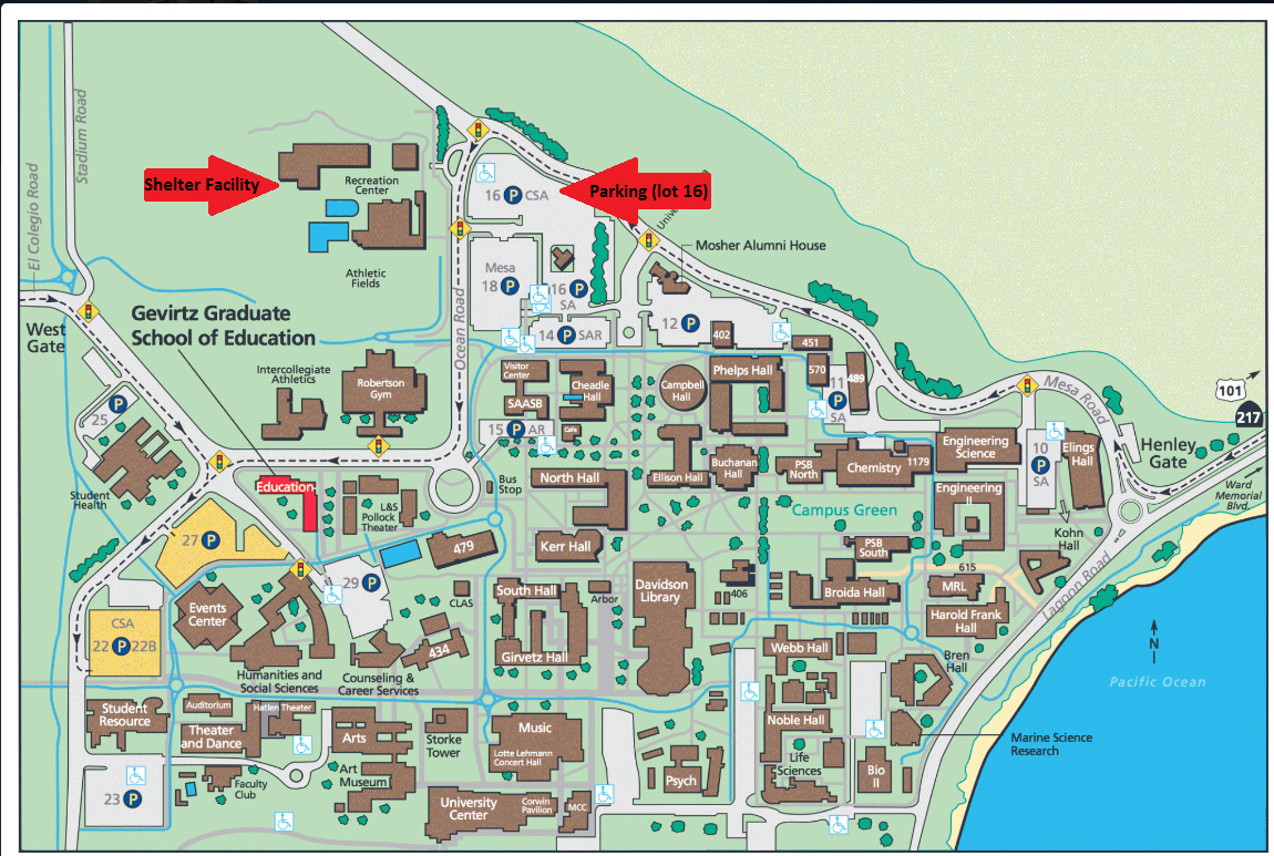
- UC Santa Barbara – Santa Barbara Multi Activity Center, 516 Ocean Road, Santa Barbara, CA (Evacuees should enter UCSB through the main east entrance, park in parking lot 16. Staff will guide you to the Center).
Road Closures
Road closures continue to impact Highway 150 and Highway 33, as well as many other city and county roads.
Per California Highway Patrol (as of 7:30 a.m. on Wednesday):
- Hard Closure- SR-150 at Reeves Road (east end Ojai Valley)
- Hard Closure – SR-150 at Stonegate (Santa Paula)
- Hard Closure – SR 150 at Telegraph Road (Santa Paula)
- Hard Closure – SR 150 at Richmond Road (Santa Paula)
- Hard Closure – Foothill Road at Olive/Cummings/Wells/Briggs (Santa Paula/Ventura area)
- Casitas Springs area – Creek Road north of Hwy 33 closed.
- CLOSURE UPDATAE: Ojai Area – Traffic is currently open for Hwy 150 (Casitas Pass Road) to US 101 (Carpenteria)
School Closures
As of 9:00 a.m. on Wednesday:
- ACE Charter High School
- Briggs School District
- Conejo Valley Adult Education
- Conejo Valley Unified School District
- CSU Channel Islands
- Fillmore Unified School District
- Hueneme Elementary School District
- Mesa Union Elementary School District
- Moorpark Unified School District
- Mupu Elementary School District
- Ocean View School District
- Ojai Unified School District
- Oxnard Elementary School District
- Oxnard Union High School District
- Pleasant Valley School District
- Rio Elementary School District
- Saint Anthony’s School
- Santa Clara Elementary School District (Santa Paula)
- Santa Paula Unified School District
- Simi Valley Unified School District
- Somis Union
- University Preparation Charter School
- VCOE Career Education Center Sites
- VCOE-Operated School Sites and Classrooms
- Ventura Charter School
- Ventura Unified School District
- Moorpark College
- Oxnard College
- Ventura College
- Thomas Aquinas College